Just ask the animals!
Using animal behaviour data to better inform mathematical models of animal movements
Many animals are adapting to human encroachment of their natural habitats. Carnivores in particular require territories of sufficient size and so are often forced to move between numerous small habitat patches. To date, scientists often use mathematical models to predict these important routes, but fishers fitted with GPS sensors are now showing that their calculations may be missing the mark if they ignore animal behaviour.

Corridors are spaces that receive too little attention and yet are vitally important. How else would we get from the bedroom to the bath or from the couch to the kitchen? Without the hallway in between, we would starve on the sofa, unable to reach our food. In the wild the areas that connect animals’ living spaces are known as corridors. It is vital for the conservation of many species that animals can move freely and safely from their hunting grounds to their mating areas, for example. If a new road is built through the middle of an important corridor, it may put an entire population at risk.
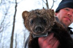
In general, calculations predict which routes the animals will use. Working with colleagues from the USA, Martin Wikelski and his doctoral student Scott LaPoint from the Max Planck Institute for Ornithology in Radolfzell and the University of Konstanz have let the animals define their own routes. They fitted fishers (mammals of the marten family) with GPS sensors and then observed their movements over the course of three winters near the city of Albany in the US state of New York. In doing so, they discovered that the fishers selected completely different routes from those predicted by the models.
“I was really astonished at how bad the models were”, says Wikelski, who heads the Department of Migration and Immunoecology at Radolfzell. The two mathematical models together managed to correctly predict only 5 out of 23 corridors. The “Least-Cost Path Analysis” model, with only one correct prediction, fared worse than the “Circuit Theory” model, which at least managed five hits.
The equations mainly use information about the habitat preferences of the animals. Since fishers spend most of their time within forests and avoid open spaces, it was assumed that this rule would also apply to their corridors. “That assumption was not true, as the animals were much more flexible in their willingness to use corridors composed of a variety of habitat types, not just forests”, notes Scott LaPoint. They scampered through alluvial and deciduous woods, over meadows, fields and even man-made landscapes such as golf courses and cemeteries, to get from one place to another.
They didn’t even draw the line at crossing streets. However, instead of exposing themselves to the dangers of trying to cross over six-lane motorways, the clever creatures instead passed beneath the motorways through old drainage pipes. “I would never have thought it, because with all we know about these shy animals, it didn’t seem possible that they would use such potentially dangerous structures” says an amazed Martin Wikelski.
Landscape planners and environmentalists are interested in wildlife corridors because they are considered worthy of special protection. Corridors facilitate a healthy spread of the animals, maintain gene flow between populations, and thereby reduce the risk of extinction. They can also be very expensive, so it is important that our corridor model predictions are accurate and that we make sure that animals are indeed using them. “To do so we should ask the animals what they need,” explains Wikelski, “and by monitoring their movements, in effect we have actually created a way for the animals to communicate with us humans.”
Scott LaPoint and Martin Wikelski’s work suggests we should just ask the animal: “What do you think? What do you want?” This could make landscape planning simpler and more transparent, and we could even learn something along the way.
CS/HR


