The fate of the big rain
Max Planck researcher are investigating the interplay of dry season and monsoon in India and the future outlook for water resource availability
Climate change affects people both globally and regionally. Pankaj Kumar, for example, who works at the Climate Service Center and the Max Planck Institute for Meteorology in Hamburg, is investigating the interplay of dry season and monsoon in India. He wants to discover the future outlook for water resource availability on the subcontinent. Aiding him in this quest is the REMO software program developed by Daniela Jacob and her team at the Hamburg-based institute.
Text: Tim Schröder


The air in May is hot and humid as it moves to the southwest after crossing the equator over the Indian subcontinent. It has traveled thousands of kilometers across the Indian Ocean, becoming saturated with water vapor. The clouds trail along with their fat, rain-laden bellies, and it takes very little to tear them open: an obstacle, perhaps a few mountains. As soon as they reach the southwestern tip of India and chafe against the mountains of Kerala, the clouds are forced upward and burst. It rains for weeks: the monsoon has arrived.
Life is reawakened by the monsoon
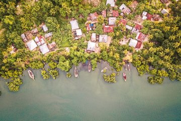
The leaden mass of clouds navigates around the mountain slopes and finally spreads over all of India as far as the Himalayas. The rain falls on parched ground, fills creeks and rivers. Trickles swell to streams. The water engulfs paths, fields and villages. People wade along, knee-deep in water, while cars create small bow waves in the flooded streets. Yet for the Indians, this is no catastrophe: it has been dry for months. Now, life is reawakened by the monsoon.
The monsoon brings almost enough rain for an entire year – drinking water and water for fields and plantations. It’s been that way for centuries. India’s population is 1.2 billion and growing. As it grows, so, too, does the amount of food the subcontinent must produce if it is to feed all of its people. At the same time, there is increasing anxiety that climate change could throw the interplay of dry season and monsoon downfalls out of kilter in just a few decades. What if the rain comes late or early? What if it changes its duration? What if it doesn’t come at all?
When the Intergovernmental Panel on Climate Change (IPCC) warns that the writing is on the wall and the average global temperature could rise by more than 2 degrees Celsius, it really means nothing at all – because the real effects of climate change are seen on the ground: in the countryside, on the coasts, in cities. Change comes in many forms. The global climate model grid is too coarse to gauge what will happen at the local level.
Pankaj Kumar is one of the scientists studying the finer details. Working at the Climate Service Center and the Max Planck Institute for Meteorology in Hamburg, he is investigating the future outlook for water resource availability in India. To do this, he uses the REMO regional model, an elaborate software program that took meteorologist Daniela Jacob and her team at the Hamburg-based institute years to develop. Kumar is the only Indian researcher in
Jacob’s group. REMO is a kind of magnifying glass that assesses the climate outlook on a small scale. It zooms into the regions, into valleys, mountain forests and big cities.


The global climate models (GCMs) the IPCC uses are rather coarse in comparison. They divide up the entire globe into a grid of weather squares measuring approximately 200 x 200 kilometers each. Only for a very small number of studies do they go down to 100 x 100 kilometers. They analyze airflows, air pressures, temperatures and winds. Above all, however, they simplify. By human standards, 200 kilometers is a long distance. A lot happens in 200 kilometers – the landscape changes, the weather changes. The average data for a 200-kilometer square gives no real indication of the peculiarities of a region.
The narrow boot of Italy, for example, falls right through the global climate grid: Italy = sea. Unfortunately, there is as yet no computer powerful enough to calculate worldwide climate for decades for each square kilometer of the Earth’s surface.
That is why REMO picks out smaller areas and analyzes climate in finer grids with squares measuring 10 x 10 or 25 x 25 kilometers. It links data from the GCM – the major air currents, areas of low pressure and important seasonal fluctuations – with details of the region – the vegetation, type of terrain, heights, depths, valleys and mountain ridges. It calculates the amount of rainfall, and whether the ground can absorb the water.
India itself is a rather large area for the REMO system to handle, so Pankaj Kumar has broken it down into a grid of 25-kilometer squares. He smiles with a certain amount of pride as he explains that his REMO simulations, linked with ECHAM (GCM of MPI) and HadCM3 (GCM of Hadley Centre) simulations under the IPCC A1B scenario, are the first to run through India’s climate and the consequences for the monsoon for the entire 21st century. Previously, only two detailed climate change studies had been carried out for India, and both covered only the last 30 years of this century, or the decades when climate change issues look set to become really big.
Kumar set the computer to calculate 15 decades – from 1950 to 2100. He ran through several different simulations in order to check the individual findings, and came up with striking results: “We now have to assume that annual precipitation will decrease by 5 to 20 percent by the middle of the century over central India and the plains of north India,” says the researcher.
This applies particularly to the most productive agricultural region, the plains of northern India, which is watered by the Ganges River. Many hectares of land on the Ganges plain are irrigated by the waters of the great river and the rainfall from the monsoon. For now, Kumar can only provide numbers. What his Indian compatriots will be able to do in the future is still open.
. The data for the prediction of the climate are correspondingly accurate, as the two graphs on the right show.")

When Daniela Jacob began developing REMO in the mid-1990s, she was interested only in the Baltic Sea. How would its climate change? In time, though, the Baltic Sea became too small for her. “We wanted to create a tool to discover what climate change really means,” she explains. “We are doing indepth fundamental research, but what I have really always wanted is to create something of practical relevance.”
While writing her diploma thesis at the Technische Universität Darmstadt, Jacob modeled the transport of acid rain. She simulated and analyzed cloud formation in land-sea breeze systems for her dissertation, then simulated the blustering behavior of snowstorms during her stay in the US. Then she moved on to the climate of the Baltic Sea.
Jacob came to grips with the simulation of regional climate phenomena by a long, in-depth process. Then REMO went into operation in 2006. Along with Guy Brasseur, former head of the Max Planck Institute for Meteorology, Jacob was strongly involved in the foundation of the Climate Service Center, an independent institute in close proximity to the Max Planck institute that provides regional climate simulations as a service.
Two decades of mental effort have gone into remo
“We get lots of inquiries”, says Jacob. “Museum curators who want to know how the climate in their city is changing so that they can protect their works of art from excessive humidity, as well as shipping offices and power plant operators, for example.” How often will the water levels in rivers be low? How many weeks per year will the Rhine and Moselle be impassable? When will power plant operations have to be curtailed because of a lack of cooling water? Forestry officials ask where in Germany the common beech will die out, and farmers want to know if there will be enough frosty nights for curly kale to develop its flavor.
“We don’t give weather forecasts, of course. What we do is calculate probabilities about how the climate might develop at our doorsteps,” says Jacob. It sounds so simple, yet almost two decades of mental effort have gone into REMO. The challenge was to link a number of parameters in such a way that they generated a true image at the end of the process. The researchers use “re-analysis” to check whether the model works. They set the software to calculate past events and use real measurements to ascertain whether the simulation matches the real-world data.
REMO’s usefulness is evident from the fact that more than 40 institutions around the world are already using it. Of course, there are other regional models, such as that of the renowned Met Office Hadley Centre in Exeter, UK. Pankaj Kumar used this model data for some of his Indian studies, and the results showed almost the same trend: the level of monsoon precipitation is decreasing. For India, the question that remains is how to respond to this change. The international project High-Noon, involving Kumar and Daniela Jacob’s research group, is seeking to provide an answer. The project will try to clarify how water resource availability will change in northern India, and how much water will flow through the Ganges, which is used by millions of Indians for drinking water and to irrigate millions of hectares of land.
Kumar has outlined the future of the monsoon, but there is a whole range of other influencing factors that the international research team plans to investigate – such as the influence of human activity. “Our REMO analyseshave shown that the irrigation of fields in the warm Indian climate directly influences precipitation in the Ganges region – heavy irrigation leads to high evaporation and thus to heavy rainfall,” says Jacob. “It is factors such as these that make the use of regional models so challenging.”
It is fully unclear as yet to what extent the snow and glaciers of the Himalayas influence water resource availability in the lowlands. The high mountain glaciers are an unknown variable; nobody has ever really calculated how much water they release. Two years ago, however, one of Jacob’s doctoral students developed a kind of “glacier module,” a software component for REMO that simulated the behavior of glaciers in the Swiss Alps. There was plenty of data available for the researcher to feed into the model. That data showed that only a small percentage of water in the Rhine comes from glaciers. Now the glacier module is to be coupled up for the India simulation. The situation in the Himalayas is different. Fahad Saeed, one of Kumar’s colleagues at the Max Planck institute, is familiar with the data for his homeland of Pakistan. “About 70 to 80 percent of the water that flows through the Indus comes from the mountain glaciers,” explains the scientist, whose research focus is the western Himalayas. Kumar is concentrating on the central region.
No one glacier is like the next


The relevant data is not yet available for India. Pankaj Kumar intends to prepare initial estimates by next year, when the HighNoon project winds up. “The size of the glacier’s surface and its thickness are important to us”, says Kumar. “Of course, it is hard to determine the thickness, but mathematical approximations are sufficient for now.”
Devoted glaciologists would tear their hair out in the face of such simplifications, because no one glacier is like the next. Their structures are different, as are their densities. Some are full of clefts and fissures, while others are dense and lie heavily on the crags. For REMO, though, it is enough for now to make a rough estimate of their thickness.
Then there is the reflecting power, the albedo. Dark glaciers absorb more heat, melt more easily and release more water, while glistening white snow on the ice crust throws solar radiation back like a mirror.
Consequently, mass and albedo are important factors in predicting the future of glaciers. The HighNoon team includes Indian hydrologists who use this data to calculate how much water flows from the mountains – a vital piece of information for those who live around the Ganges.
High-Noon also aims to discover how the population can adjust to possible changes. Indian agricultural scientists and other experts are speaking with people on the ground. In recent weeks, they took the first step of meeting with local politicians and farmers in the villages and cities along the Ganges – in the northern district of Udham Singh Nagar, practically at the foot of the mountains, in the central Ganges plain around the holy city of Allahabad and in the West Midnapore district of the lower Ganges.
“Simulations are always fraught with uncertainties”
 in a discussion at the Max Planck Institute for Meteorology in Hamburg.")

“Obviously, climate simulations are always fraught with uncertainties,” points out High-Noon project leader Eddy Moors of Wageningen University in the Netherlands. “So we have to come up with measures against the consequences of climate change that are somewhat flexible.” This could include building smaller, cheaper dams or infiltration basins using natural materials to store rainwater from the monsoon, so that sinking groundwater levels could be topped up in many places. In other cases, farmers could switch to hardier plants or different irrigation techniques.
The researchers are also interested in the Tehri Dam in northern India, an enormous and highly controversial structure that has stored water for the city of New Delhi in recent years and generates hundreds of megawatts of power through its powerful turbines. “We want to find out how the dam should be managed if the climate changes,” says Moors. How should the outflow be regulated in order to prevent flooding and flash floods after heavy rain, or to manage water availability in periods of drought? What will happen to power supplies if the glacial melt pattern changes?
The HighNoon project has reached the halfway mark. It is still carrying on with older international projects, but many questions remain unanswered. Moors and Kumar hope to make significant progress over the coming year. Kumar is confident that his work will be fruitful. “The project lays important scientific foundations that are needed before many other measures can be taken.” Then he smiles again, glances over at his colleague Fahad and adds, “And then there’s the fact that you have an Indian and a Pakistani sitting here together, working on a detailed regional simulation for both India and Pakistan that is quite unique and even includes glacial water in its calculations. We’ll find the answers to lots of questions."
GLOSSARY
Monsoon
The monsoon is a large and continuous air current in the tropics and subtropics. It changes direction twice a year and is driven by the position of the Sun, which changes during the course of the year. The high altitude of the Sun in the equatorial region causes the land and sea to heat up to different temperatures, and this leads to marked differences in pressure, generating winds. When the monsoon current blows after crossing the equator in the westerly to southwesterly direction, it carries large amounts of water that it then discharges as heavy rainfall. This sometimes causes major flooding. In India, the main monsoon rains fall during the months of June through September.
REMO
REMO stands for Regional Climate Model or Regional Climate Modeling. The REMO software was developed at the Max Planck Institute for Meteorology in Hamburg and calculates future climate for individual regions. Its underlying data grid is set to 10 x 10 kilometers or 25 x 25 kilometers, a scale that enables predictions to be made about possible climate change even for specific rural districts or conurbations. Global climate models have a much coarser spatial resolution, since calculating the world’s climate on a small scale would exceed the capacity of today’s supercomputers. Global models work with 100- or even 200-kilometer grids.
HighNoon project
The HighNoon project is an EU project funded under the 7th European Framework Programme for Research. The project aims to clarify how water resource availability will change in northern India. It brings European researchers together with their colleagues from a number of Indian research institutions, including meteorologists, hydrologists and agricultural scientists. (http://www.eu-highnoon.org/)